Los Nr. 652 | A299
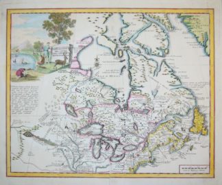
0652-Kanada, Neufundland, 7 Kupferstichkarten: 5 x Bellin aus Atlas portatif 1773 // “Terre-Neuve” (Neufundland), Raspe/Nürnberg um 1762 // Albrizzi, rare altkol. Kupferstichkarte Ostkanada & Neuengland, Venedig um 1750
€ 20
€ 170
€ 170
Kanada, Neufundland, 7 Kupferstichkarten: 5 x Bellin aus Atlas portatif 1773 // "Terre-Neuve" (Neufundland), Raspe/Nürnberg um 1762 // Albrizzi, rare altkol. Kupferstichkarte Ostkanada & Neuengland, Venedig um 1750
Jacques Nicolas Bellin, 1703 Paris - 1772 Versailles, französischer Kartograph, Ingenieur-Geograph, Hydrograph der Marine, hier: 5 altkolorierte Kupferstichkarten aus dem "Atlas portatif" ("Carte de la Baie de Hudson" / "Carte des Lacs du Canada" / "Carte de l `Acadie et Pais Voisins" / "Carte du Cours du Fleuve de St. Laurent" / "Suite du Cours du Fleuve de St. Laurent"), je 26,5 x 39 cm (Blattgröße) // "Carte von der Insel Terre-Neuve entworfen von Bellin", altkolorierte Neufundland Kupferstichkarte von Raspe/ Nürnberg um 1762, 22,5 x 22,5 cm oben links die Titelkartusche // Giovambattista Albrizzi, "Carta Geografica del Canada Nell America Settentrionale", 33 x 42,5 cm mit breitem Plattenrand. (Seltene und dekorative Karte um 1750 von Ostkanada und Neuengland, einschließlich der Großen Seen, Labrador und Hudson's Bay. Auf der Karte gibt es zahlreiche Hinweise auf lokale Besonderheiten, zahlreiche Festungen sind ebenso verzeichnet wie die Indianerstämme. In der Mitte links befindet sich eine lange Notiz über Lahontans Longue River of the West und darüber eine kunstvolle Titelkartusche), aus: "Atlante Novissimo del Sigr. Guglielmo de L'Isle", Venedig. (Volumen Secondo MDCCL-1750)